§ 12.11.54 - Measure
No Script CommandThis operator allows you to measure various spatial aspects of an image using area selections.
There are two ways to set it up:
- If you know how much distance a pixel represents, you can directly enter that in the Units Per X Pixel and Units per Y Pixel controls.
-
If you have known vertical, horizontal, or both distances (such as a scale of miles, which typically provides a horizontal reference), you can pull a rectangle out to cover that known space, then click one of Calc both XY, Calc only X or Calc only Y buttons, and iToolBox will calculate the units per pixel for you.
Depending on which of the three buttons you choose, there will be two or three values you can set. The top one or two values, respectively, set the primary scale(s) as specified.
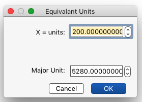
For instance, if a map has a horizontal 200 foot scale on it, you'd carefully select the length of the scale with a rectangle, then click Calc only X, then enter 200 in the X = Units field. If you want your readout in feet just as the scale indicates, then leave the Major Units field set to 1.
However, for example, you might prefer your measurements in miles; in that case, enter 5280 into the Major Units field and iToolBox will adjust the readings to miles (because there are 5,280 feet in a mile.
Prefer kilometers? There are 3,280 feet in a kilometer, so just enter 3280 into the Major Units field and now your measurements will be converted from feet to kilometers.
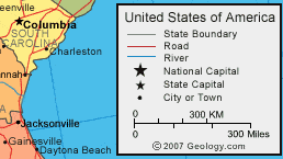
The more detailed the image, or in other words the more pixels per unit distance it has, the more accurate the Measure operator will be.
For instance, in image A below, a scale of 300 miles takes up 107 pixels, whereas in image B, a scale of 300 miles takes up 220 pixels. The Measure operator will be about twice as accurate when working with image B.
The Measure operator indicates very precise results, but how much you can trust that precision is entirely dependent upon the accuracy issue explained in the previous tip. The precision is provided by the operator in order to accommodate those circumstances when a very precise image is under scrutiny; for low precision images, you're going to get low-precision results — in such cases, you must consider the result only an approximation.
Further, there are two fundamental issues with precision: One is the source of the image itself; is the image geometrically true to the region it presents, or is it distorted? The other is the resolution the image was sampled in; the higher, the better, given that the sampling is not geometrically distorted.
Both distortion and low sample density can result in numbers that look precise, but really are not at all.
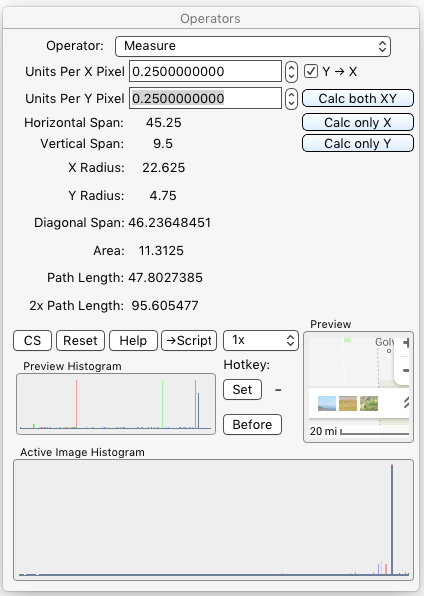
The Measure operator dialog image above shows results from using the scale of 20 miles in the following image to set both the Units Per [axis] Pixel values via the Calc only X button after pulling a rectangle along the scale of miles...
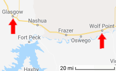
...the distance was measured using a polygon area selection along the road with open figure turned on (so the polygon would not automatically close and consequently incorporate in the measured result the path back to the start of the polygon.) The Path Length is shown as 47.8 miles, which is very close to correct, even given the low precision of the map itself, which only offers a resolution of 4 pixels per mile. However, it is a very accurate four pixels per mile; the map here came from Google Maps, which presents its map images very nicely in highly accurate pixels-per-unit-area, even when the map images are relatively small.
, Previous Page . Next Page
t TOC i Index k Keyboard o Operators g Glossary c Changes
![]()
on February 27th, 2026 at 17:38 MT
| Please consider supporting my iToolBox development efforts with a small PayPal donation. |