| This is a child page. You can use Parent in the quick nav bar at the top or the bottom of the page to navigate directly back to the parent of this page. Some child pages are more than one level deep, and in that case will require more than one Parent click to reach the outermost document level. |
§ 16.82 - Flat Map
| Quick Reference to Scripting Command |
| a=FLATMAP(cliff thresh, sea level) |
| Items in CAPS are 0/1 or ranges with more options than just 0/1. Ranges other than 0/1 are indicated by brackets, such as [0-2]. |
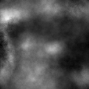 Source Heightfield |
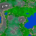 Flat Map Output |
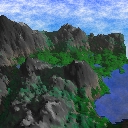 Landscape Output |
The flat map operator is designed to produce a map that relates directly to the output that the Landscape operator generates in 3 dimensions.
This operator can use Pixel Transfer Modes to generate output image and layer data. These modes add a great deal of flexibility to what you can do with this operator. Only operators that create new image or layer data use pixel transfer modes. Also, plugins may use them if the plugin designer takes care to use the plugin masked write services.
§ 16.82.1 - Flat Map Controls
§ 16.82.1.1 - Trends
Operator dialog controls that have a Trend button next to them offer animation functionality. Trend allows you to set that variable over a set of frames. Each frame of the animation can be thought of as a slice of time. The trends allow you to alter some, all, or none of the variables for a particular time slice. Variables that have multiple states can be set to any of a number of values in the trend. Variables that are either on or off can only have an on or off value in the trend. You will notice that the trend graphs have equidistantly spaced vertical lines. Each of these lines represents a frame in the animation. The number of frames can be altered using Sequence controls... in the TimeLine pull down menu. Animation lengths of 100 - 999 frames will be represented with a vertical bar being 10 frames, and animation length greater than 1000 frames will have a vertical bar for every 100 frames. Click here to view more information on Trends.
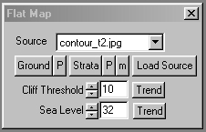
§ 16.82.1.2 - Ground
This control allows you to load a 256-color palette to use as an altitude cued color scheme for the output landscape where the land is less steep than specified via the steepness control. The P control immediately to the right of the Ground control allows you to actively edit this palette at any time. If you would like to learn more about the palette controls, Click Here.
When this operator is dragged into the TimeLine, palettes will automatically trend to the next palette, if another exists in the TimeLine.
§ 16.82.1.3 - Strata
This control allows you to load a 256-color palette to use as an altitude cued color scheme for the output landscape in areas where the land is steeper than provided for in the steepness control if steep is checked. The P control immediately to the right of the Strata control allows you to actively edit this palette at any time. If you would like to learn more about the palette controls, Click Here.
When this operator is dragged into the TimeLine, palettes will automatically trend to the next palette, if another exists in the TimeLine.
§ 16.82.1.4 - m
The m control presets a convenient "moonscape" palette.
§ 16.82.1.5 - Load Source and Source Drop-Down List
These allow to to choose the image that will be used as the input heightfield for the landscape generator.
§ 16.82.1.6 - Cliff Threshold
This sets the threshold where coloration for the landscape switches from the ground palette to the strata palette. The higher the setting, the less ground will be marked as exposed rock. The concept of "cliffing" is that when the ground is steep, it is less and less easy for vegetation, snow or any "ground cover" to cling to the landscape, and so the idea is that depending on the altitude we choose a position in the strata palette colored appropriately for exposed ground without cover at that particular altitude. The example strata palette goes from browns (dirt) through a series of greys and blacks (rock) as it goes "higher".
There is no Cliffing switch; if you'd like to disable cliffing, set the Cliff Threshold to 255.
§ 16.82.1.7 - Sea Level
Heightmaps are interpreted as altitudes from 0 to 255 based on the luma of the pixels in the heightmap. The Sea Level setting will cause the heightmap to be "flooded" at the height it is set to and below. If you want to disable flooding, set this to -1.
, Previous Page . Next Page t TOC i Index o Operators g Glossary
Copyright © 1992-2007 Black Belt Systems ALL RIGHTS RESERVED Under the Pan-American Conventions
WinImages F/x Manual Version 7, Revision 6, Level A
![]()